
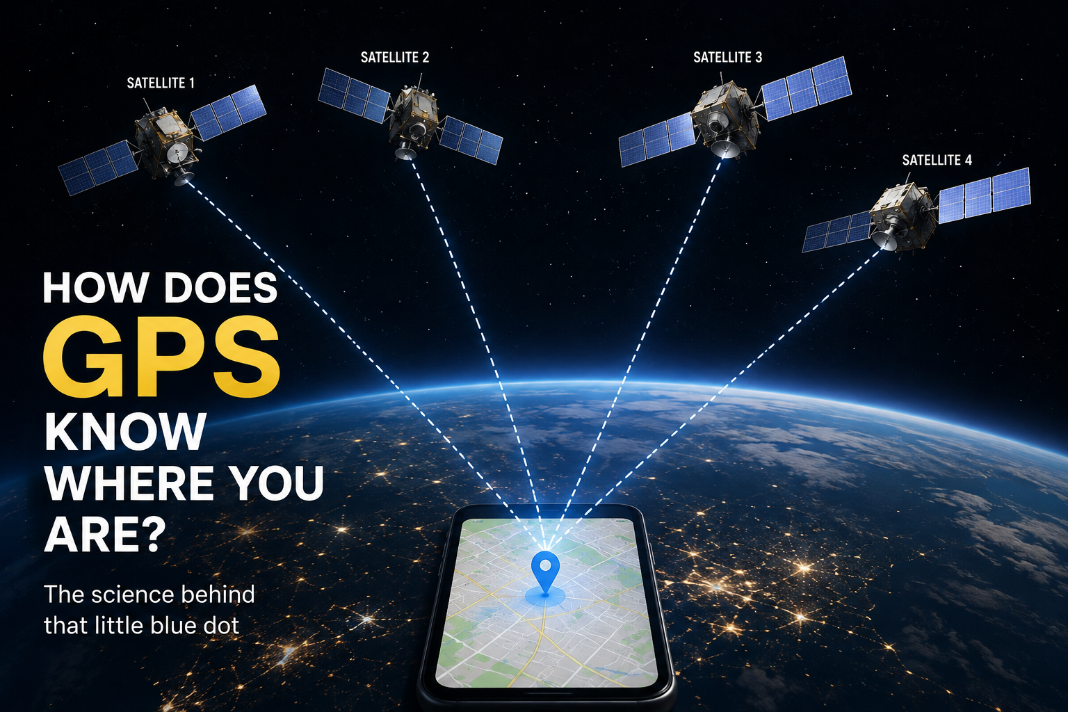
How Does GPS Know Exactly Where You Are?
Have you ever opened Google Maps, typed in a place, and watched a little blue dot show exactly where you are?
It can feel almost like magic.
Your phone doesn’t have eyes. It can’t see the road you are standing on. It doesn’t know which building you are inside. Yet somehow, it can tell you where you are and even guide you to another place.
So, how does GPS know your location?
The answer involves satellites, very accurate clocks, radio signals, and a little bit of mathematics.
Let’s understand it step by step.
First, What Is GPS?
GPS stands for Global Positioning System.
It is a navigation system that helps determine where something is on Earth.
GPS was originally developed by the United States, but today it is used all over the world.
Your smartphone can use GPS to:
- Find your current location
- Give you directions
- Track your journey
- Help you find nearby places
- Estimate how long it will take to reach somewhere
- Help apps know where you are, when you give them permission
But there is one important thing to understand:
Your phone doesn’t send a signal to a GPS satellite asking, “Where am I?”
Instead, the satellites send signals towards your phone, and your phone uses those signals to work out where it is.
Where Are These GPS Satellites?
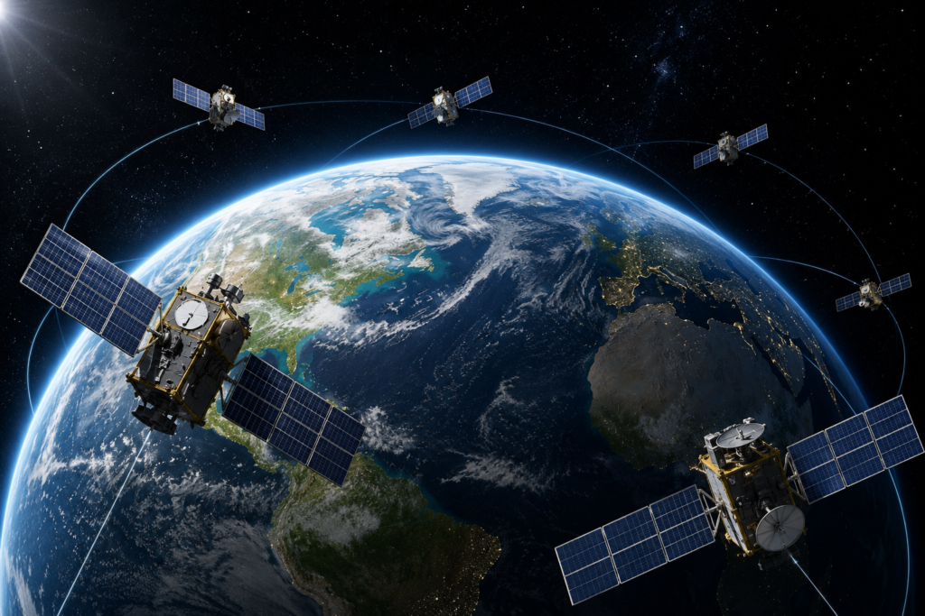
There are many GPS satellites orbiting Earth, roughly 20,200 kilometres above us.
They are constantly moving around Earth and sending radio signals towards the planet.
These signals contain important information, including:
- Which satellite sent the signal
- Where the satellite is
- The exact time the signal was sent
Your phone receives these signals and uses them to calculate your location.
But how can a signal from a satellite tell your phone where it is?
This is where the clever part begins.
Your Phone Measures Time
Imagine someone standing far away from you and shouting:
“Hello!”
You hear the sound a little after they shouted it.
If you knew exactly when they shouted and exactly when you heard the sound, you could work out approximately how far away they were.
GPS works using a similar idea.
But instead of sound, GPS uses radio signals.
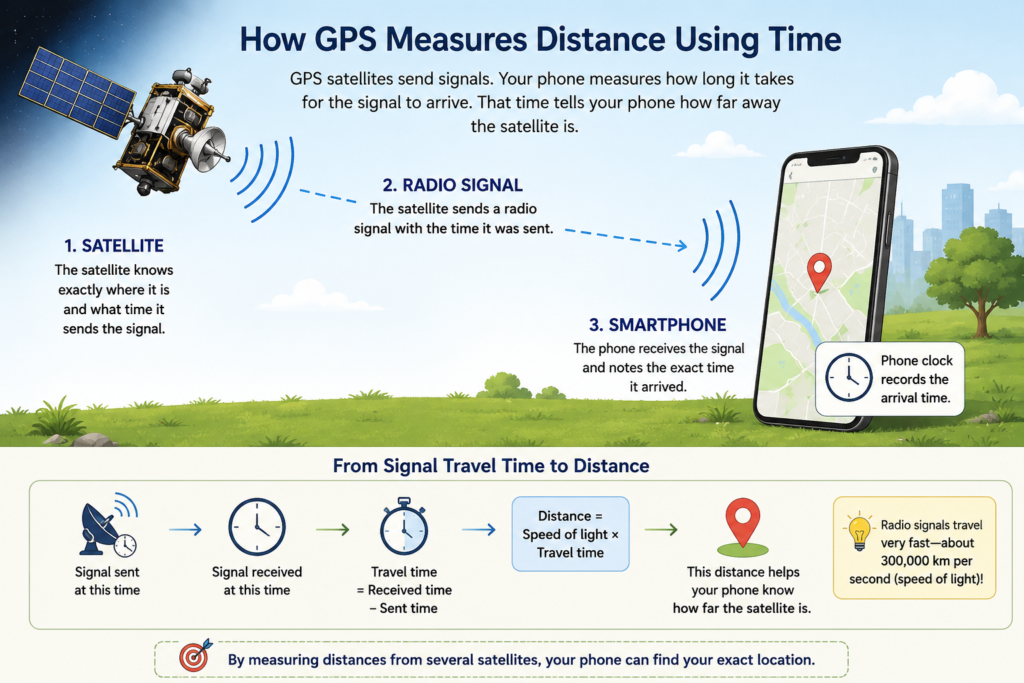
Radio signals travel extremely fast — at about the speed of light.
Your phone measures how long it took for the signal to travel from the satellite to your phone.
Because we know:
Distance = Speed × Time
your phone can estimate how far away the satellite is.
For example, if your phone calculates that a signal took a certain amount of time to reach it, it can estimate the satellite’s distance from you.
But one satellite isn’t enough.
One Satellite Isn't Enough
Imagine you are lost somewhere and someone tells you:
“You are 20 kilometres from me.”
Does that tell you exactly where you are?
No.
You could be anywhere within a circle 20 kilometres around that person.
Now imagine a second person says:
“You are 15 kilometres from me.”
Your possible location becomes much smaller because the two circles intersect.
Add another measurement and the possible location becomes smaller still.
GPS uses the same basic idea, but in three dimensions.
This process is called trilateration.
What Is Trilateration?
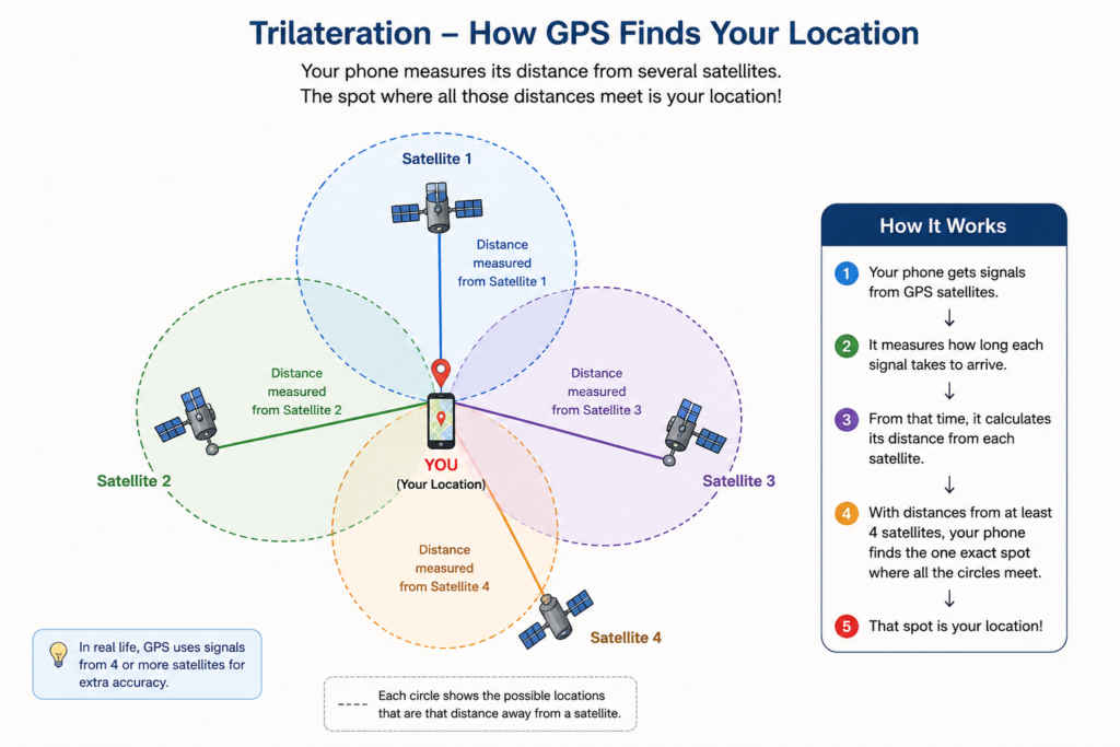
Trilateration is a method of finding a location by measuring distances from known points.
Think of the GPS satellites as several known points in space.
Your phone measures its distance from different satellites.
When it combines these measurements, it can determine where you are.
You can think of it like this:
Satellite 1 → How far am I from it?
Satellite 2 → How far am I from it?
Satellite 3 → How far am I from it?
Satellite 4 → How far am I from it?
The phone combines all these measurements and calculates your position.
Usually, signals from at least four satellites are needed for a reliable GPS position.
Why Does GPS Need Four Satellites?
This is one of the most interesting parts.
Your phone needs to figure out more than just its location.
It needs to determine:
- Your position from side to side
- Your position from front to back
- Your height
- A correction for the phone’s clock
GPS satellites have extremely accurate atomic clocks.
Your smartphone’s clock, however, isn’t nearly as precise.
Even a tiny timing error can create a large error in your calculated location.
So the fourth satellite helps your phone correct its timing and calculate a much more accurate position.
That’s why GPS generally uses signals from four or more satellites.
How Does Your Phone Know Which Satellite Is Which?
Every GPS satellite continuously sends information about itself.
The signal tells your phone things such as:
“I am satellite number X, and this is where I am in space.”
Your phone receives signals from several satellites at the same time.
It then compares the signals and calculates the distances.
A computer inside your phone does all the complicated mathematics in just a few seconds.
You simply see a blue dot appear on the map.
Is the Blue Dot Always Exactly Correct?
Not always!
GPS can be extremely useful and accurate, but your phone doesn’t always know your position down to the exact centimetre.
You may sometimes notice that the blue dot:
- Appears on the wrong side of a road
- Jumps slightly from one place to another
- Shows you inside a nearby building
- Takes a few seconds to find your location
Why does this happen?
GPS signals can be affected by things around you.
Why Can GPS Sometimes Be Wrong?
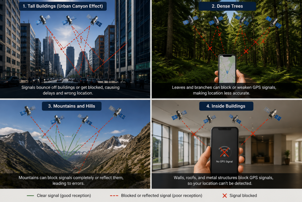
1. Tall Buildings
In cities, radio signals can bounce off buildings before reaching your phone.
This can confuse the location calculation.
This is sometimes called the urban canyon effect.
2. Mountains and Trees
Large objects can block or weaken GPS signals.
If you are surrounded by mountains or dense trees, your phone may have a harder time receiving good signals.
3. Being Indoors
GPS works best when your phone has a relatively clear view of the sky.
Thick walls, roofs and other structures can weaken the signals.
That’s why GPS can sometimes struggle inside large buildings.
4. Atmosphere
GPS signals travel through Earth’s atmosphere before reaching your phone.
The atmosphere can slightly affect how quickly the signals travel.
Your phone and the GPS system take these effects into account, but small errors can still remain.
Does GPS Use Only Satellites?
Here’s another interesting fact.
Your phone doesn’t necessarily depend on GPS satellites alone to figure out your location.
Modern smartphones can combine information from several sources, including:
GPS + Wi-Fi + mobile networks + other satellite navigation systems + phone sensors
This can help your phone find your location faster and sometimes more accurately.
For example, your phone may use nearby Wi-Fi networks or mobile towers to get a rough idea of where you are while it is waiting for a strong satellite signal.
This is one reason your location can sometimes appear quickly even when GPS signals aren’t perfect.
What About Other Countries?
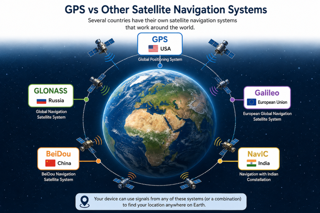
GPS is not the only satellite navigation system in the world.
Different countries and regions have developed their own systems.
For example:
- GPS – United States
- GLONASS – Russia
- Galileo – European Union
- BeiDou – China
- NavIC – India
Modern smartphones can often use signals from more than one satellite navigation system.
Using multiple systems can give your phone access to more satellites and can improve positioning.
How Does GPS Help Google Maps?
GPS and Google Maps are actually two different things.
GPS helps your phone figure out where you are.
Google Maps provides the map and directions.
When you open Google Maps, your phone can determine its location using satellite navigation and other signals.
The app then places your location on a digital map.
If you enter a destination, the app uses map data and navigation algorithms to work out a route.
So when you see:
“Turn left in 200 metres.”
your phone has combined several technologies to help you navigate.
A Simple GPS Experiment
You can actually see GPS working for yourself.
Next time you are outside, open your phone’s map application.
Look at your location.
Now walk around for a few minutes.
Watch the blue dot move as you move.
Then try the same thing inside a large building.
You may notice that the location becomes less accurate.
This gives you a simple clue about how much GPS depends on receiving good signals.
Did You Know?
🌍 GPS satellites orbit Earth thousands of kilometres above us.
⏱️ GPS depends on extremely accurate timing.
📡 Your phone receives signals from satellites rather than simply asking satellites where it is.
🛰️ Your phone can use multiple satellite navigation systems, not just GPS.
📍 The blue dot on your map is a calculated position, not a tiny tracker watching you from space!
So, How Does GPS Know Where You Are?
Let’s put everything together.
1. Satellites orbit Earth and continuously send radio signals.
⬇️
2. Your phone receives signals from several satellites.
⬇️
3. It measures how long the signals took to arrive.
⬇️
4. It calculates how far away each satellite is.
⬇️
5. Using several satellites, it calculates your position through trilateration.
⬇️
6. Your phone combines this information with other signals and sensors when available.
⬇️
7. Your location appears as that familiar blue dot on the map.
And that is how your phone can figure out where you are — without anyone sitting in space watching you!
The Big Idea
GPS may look like magic when a tiny blue dot follows you around a map, but underneath it is a beautiful combination of space technology, radio signals, incredibly accurate clocks and mathematics.
The next time Google Maps tells you:
“You have arrived.”
you’ll know that several satellites, your phone, and some very clever mathematics helped you get there.
Frequently Asked Questions
1. Does GPS work without the internet?
Yes. GPS itself does not require an internet connection. However, apps such as Google Maps may need internet access to download maps, traffic information and other data.
2. Can GPS work indoors?
Sometimes, but it is usually less accurate indoors because buildings and roofs can weaken GPS signals.
3. How many satellites does GPS use?
The GPS system has a constellation of satellites that provide global coverage. Your phone typically uses signals from several satellites at the same time to calculate your position.
4. Is GPS always 100% accurate?
No. GPS accuracy can be affected by buildings, trees, mountains, atmospheric conditions and other factors.
5. Does GPS track me all the time?
GPS satellites simply transmit signals. Your phone calculates its position from those signals. Whether an app stores or shares your location depends on the permissions and privacy settings you give that app.
🛰️ Did you know?
The GPS system was designed with 24 satellites arranged around Earth. Today, additional GPS satellites are also in orbit, providing backup and helping maintain reliable coverage.
Related Reading
If you enjoyed learning how GPS works, you might also like:
How Do Mobile Phones Make Calls?
Ever wondered how your voice travels from your phone to someone else’s phone?
How Did People Tell Time Before Clocks?
Before watches and smartphones, how did people know when it was time to work, eat or sleep?
4 thoughts on “How Does GPS Know Exactly Where You Are? | The Amazing Science Behind It”