
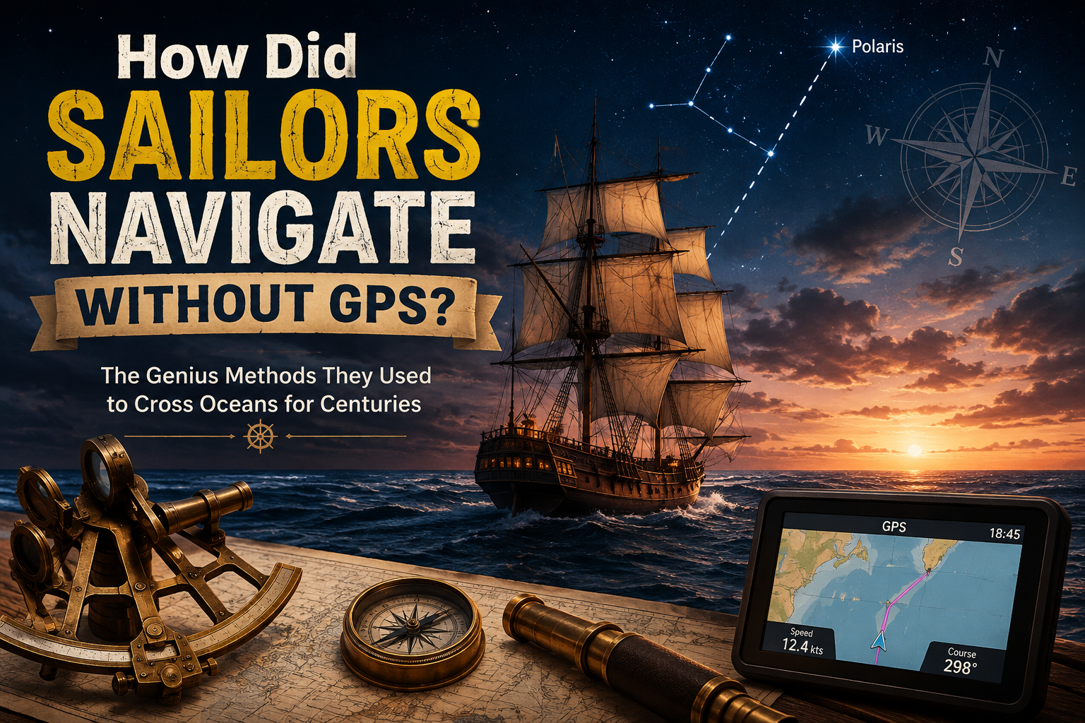
Today, getting directions is almost effortless. Open Google Maps, enter a destination, and your phone can tell you exactly where you are and which way to go.
But imagine being in the middle of the ocean, hundreds of kilometers from land, with no roads, no mobile network, no satellites, and no GPS.
How did sailors know where they were going?
For thousands of years, sailors navigated using a combination of the Sun, stars, compass, maps, landmarks, ocean conditions, and careful calculations. They also kept detailed records of their speed, direction, and time to estimate their position.
It wasn’t as precise or convenient as GPS, but skilled sailors could cross entire oceans using these methods.
So, how did sailors navigate without GPS? Let’s find out.
How Did Sailors Navigate Without GPS?
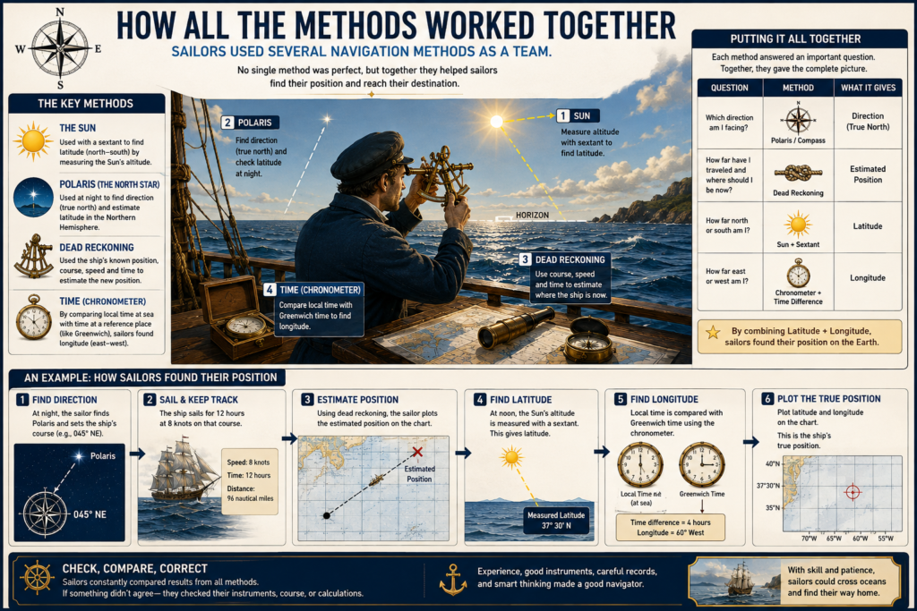
Before GPS, sailors used several navigation techniques rather than relying on a single method.
The most important were:
- The Sun and stars
- Magnetic compasses
- Dead reckoning
- Latitude and longitude
- Nautical charts
- Landmarks and coastal navigation
- Ocean depth and underwater features
- Wind, waves, and currents
- Clocks and marine chronometers
The interesting part is that these methods worked together.
If a sailor knew the direction from a compass, estimated how fast the ship was moving, and periodically checked the Sun or stars, they could build a surprisingly good picture of their location.
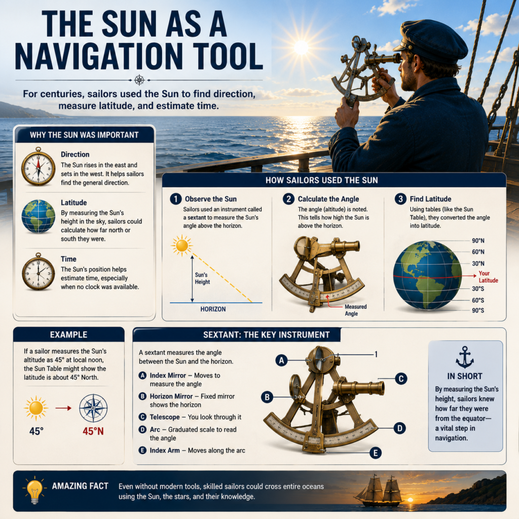
Sailors Used the Sun to Find Their Direction
The Sun was one of the most useful natural navigation tools.
We know that the Sun appears to rise roughly in the east and set roughly in the west. During the day, its position in the sky also changes in a predictable way.
Sailors could use this movement to determine direction.
For example, in the Northern Hemisphere, the Sun is generally toward the south around local noon. By observing its position throughout the day, sailors could get a rough idea of which direction they were traveling.
But the Sun could do much more than simply tell sailors east from west.
With the right instruments and calculations, sailors could use the Sun’s angle above the horizon to estimate their latitude.
And that was extremely important.
Sailors Used the Stars as a Natural GPS
At night, sailors could turn to the stars.
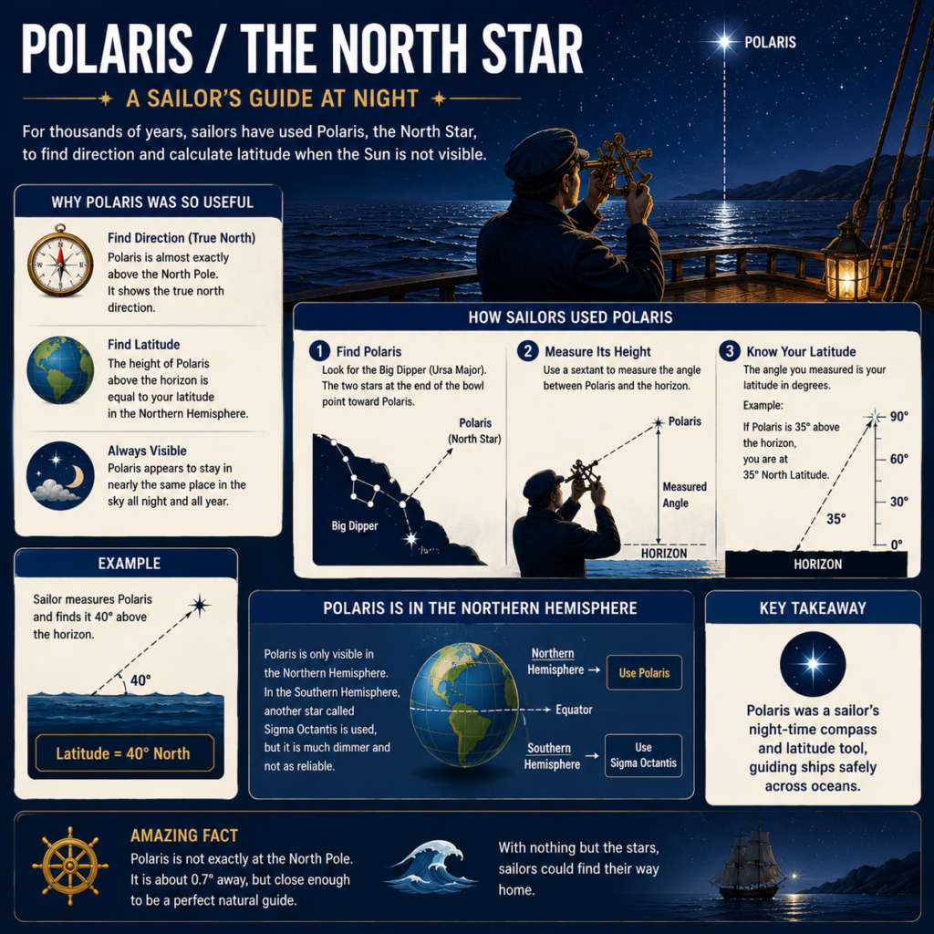
The most famous navigation star is Polaris, the North Star.
Polaris appears almost directly above Earth’s North Pole. Because of this, its position in the sky gives sailors a useful indication of their latitude in the Northern Hemisphere.
There is a fascinating relationship:
The higher Polaris appears above the horizon, the farther north you are.
For example, near the equator, Polaris appears close to the horizon. As you travel north, it appears higher and higher in the sky.
Near the North Pole, Polaris would appear almost directly overhead.
This gave sailors a natural way to estimate their position north or south.
What about sailors in the Southern Hemisphere?
There is no equally bright star sitting directly above the South Pole.
Instead, sailors learned to identify patterns of stars, particularly the Southern Cross, to help locate the direction of south.
So even without satellites, the night sky provided a giant natural reference system.
The Compass Told Sailors Which Way They Were Going
Celestial navigation could tell sailors a lot about their position, but they also needed to maintain a direction.
That is where the magnetic compass became incredibly useful.
A compass needle aligns approximately with Earth’s magnetic field and points toward magnetic north.
This allowed sailors to determine directions such as:
- North
- South
- East
- West
- Northeast
- Southwest
- and so on
A sailor could set a course, for example, toward the southwest and use the compass to keep the ship approximately pointed in that direction.
However, a compass alone could not tell sailors where they were.
It could tell you which way you are facing, but not where you are on the ocean.
That’s why sailors combined compass readings with other techniques.
Dead Reckoning: Navigation Without Knowing Exactly Where You Are
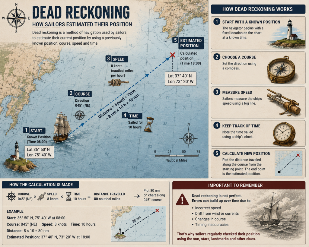
One of the cleverest techniques sailors used was called dead reckoning.
The basic idea is surprisingly simple.
If you know:
- Where you started
- Which direction you traveled
- How fast you traveled
- How long you traveled
you can estimate where you should be now.
Imagine a ship leaves an island and travels west at approximately 10 knots for five hours.
Ignoring currents and other complications, the sailors could estimate that they had traveled about 50 nautical miles west.
They could then mark their estimated position on a nautical chart.
The problem?
Small errors accumulate.
If the ship’s speed is estimated incorrectly, or the wind pushes it sideways, or an ocean current carries it off course, the estimated position becomes less accurate.
After several days, the ship could be significantly farther from its calculated position than expected.
That is why sailors needed ways to regularly check and correct their position.
Sailors Used Knots to Measure Speed
But how could sailors determine how fast their ship was moving?
They developed a clever method involving a log line.
A weighted piece of wood was thrown into the water while a line marked at regular intervals ran out behind the ship.
As the ship moved forward, sailors measured how much line passed out during a known period of time.
This gave them an estimate of the ship’s speed.
The unit knot comes from this historical method.
One knot means one nautical mile per hour.
So if a ship was traveling at 8 knots, sailors could estimate that it was covering about 8 nautical miles every hour.
That information could then be used for dead reckoning.
Latitude Was Easier to Find Than Longitude
One of the biggest challenges in historical navigation was figuring out latitude and longitude.
Latitude tells you how far north or south you are.
Longitude tells you how far east or west you are.
Finding latitude was comparatively easier because sailors could measure the altitude of celestial objects.
For example, in the Northern Hemisphere, measuring the angle of Polaris above the horizon gave a useful approximation of latitude.
The difficult problem was longitude.
And solving that problem changed navigation forever.
The Longitude Problem

Imagine you are sailing across the Atlantic.
You know your latitude fairly accurately, but how do you know exactly how far east or west you have traveled?
The key is time.
Earth rotates once approximately every 24 hours.
That means the difference between your local time and the time at a known reference location can tell you how far east or west you are.
The challenge was having an accurate clock that could continue keeping time despite:
- constant movement
- changes in temperature
- humidity
- rough seas
- and the motion of the ship
For a long time, this was a major problem.
The Marine Chronometer Changed Ocean Navigation
In the 18th century, accurate marine clocks called chronometers provided a practical solution to the longitude problem.
A sailor could set the chronometer to a known reference time before leaving port.
Then, while at sea, the sailor could determine local time using astronomical observations.
By comparing the two times, the sailor could estimate the ship’s longitude.
The principle is beautifully simple:
Earth rotates about 15 degrees of longitude every hour.
So a one-hour difference corresponds to roughly 15 degrees of longitude.
This allowed sailors to determine their east-west position far more accurately than before.
Sailors Used Special Instruments to Measure the Sky
Sailors didn’t simply look at the Sun or stars and guess their position.
They used specialized instruments.
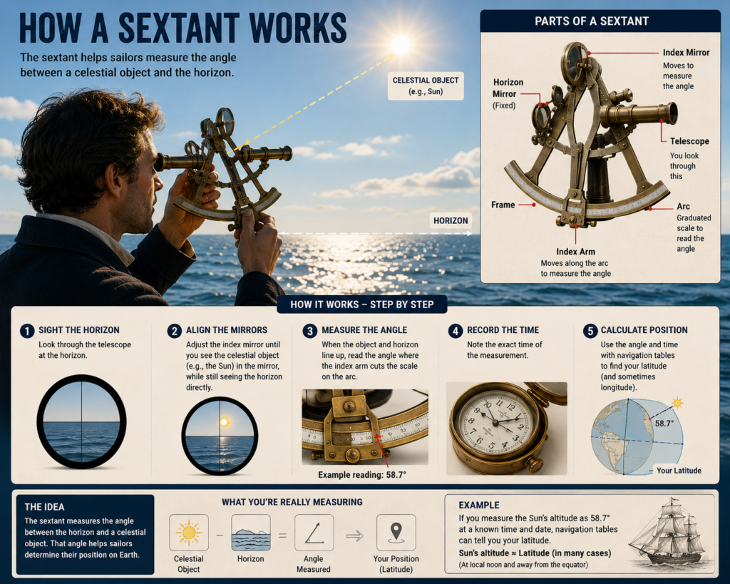
One of the most famous was the sextant.
A sextant allowed sailors to measure the angle between a celestial object, such as the Sun or a star, and the horizon.
With the correct time, astronomical tables, and calculations, sailors could use these measurements to determine their position.
Other instruments used in navigation included:
- Astrolabes
- Quadrants
- Cross-staffs
- Octants
- Sextants
These instruments became increasingly accurate over time.
Nautical Charts Were the Sailor's Maps
Sailors also depended heavily on nautical charts.
These weren’t ordinary road maps.
Nautical charts showed information that mattered specifically to ships, including:
- Coastlines
- Islands
- Ports
- Rocks
- Reefs
- Shoals
- Water depths
- Navigation hazards
- Buoys and other markers
A sailor could combine information from the chart with compass readings, celestial observations, and dead reckoning.
The chart essentially became a picture of the world onto which the sailor could plot their estimated position.
Near Land, Sailors Used Landmarks
Ocean navigation became especially difficult when a ship was far from land.
But when sailing near a coast, things became much easier.
Sailors could use visible landmarks such as:
- Mountains
- Cliffs
- Islands
- Lighthouses
- Churches
- Towers
- Headlands
By comparing what they saw with their charts, they could determine their approximate location.
This is called coastal navigation or pilotage.
Experienced local sailors could become extremely familiar with their coastline and recognize locations from surprisingly subtle features.
The Depth of the Ocean Could Also Give Clues
Here’s another clever technique: sailors could measure water depth.
A weighted line, called a sounding line, could be lowered into the water.
The sailor could then compare the measured depth with information recorded on nautical charts.
The bottom of the sea could also have distinctive characteristics, such as sand, mud, gravel, or rock.
These clues could help sailors determine where they were, especially when approaching a coast.
It was another example of sailors using the environment itself as a navigation tool.
Sailors Paid Attention to Wind, Waves, and Currents
Navigation wasn’t just about instruments.
Experienced sailors also learned to read the ocean.
They paid attention to:
- Wind direction
- Ocean currents
- Wave patterns
- Swells
- Weather
- Clouds
- Water color
- Birds
- Floating vegetation
- Marine life
For example, an experienced sailor might know that a particular current generally carried ships in a certain direction.
This information could be incorporated into their calculations.
But currents were also a major source of error.
A ship could be pointing directly toward its intended destination while an ocean current slowly pushed it sideways.
That meant the direction the ship was pointing was not always the same as the direction the ship was actually moving.
Navigation wasn’t just about instruments.
Experienced sailors also learned to read the ocean.
They paid attention to:
- Wind direction
- Ocean currents
- Wave patterns
- Swells
- Weather
- Clouds
- Water color
- Birds
- Floating vegetation
- Marine life
For example, an experienced sailor might know that a particular current generally carried ships in a certain direction.
This information could be incorporated into their calculations.
But currents were also a major source of error.
A ship could be pointing directly toward its intended destination while an ocean current slowly pushed it sideways.
That meant the direction the ship was pointing was not always the same as the direction the ship was actually moving.
What Happened When the Sky Was Cloudy?
This is where navigation became difficult.
Celestial navigation depends heavily on being able to see the Sun, Moon, or stars.
If the sky remained cloudy for several days, sailors might have to rely more heavily on:
- Compass readings
- Dead reckoning
- Estimated speed
- Wind direction
- Known currents
- Previous observations
- Nautical charts
The longer they went without being able to make a reliable astronomical observation, the greater the uncertainty could become.
This is one reason historical ocean voyages required enormous skill and experience.
How Did Sailors Know They Had Reached the Right Place?
Eventually, sailors needed to identify their destination.
Sometimes this was straightforward.
A distinctive mountain, island, lighthouse, or coastline could confirm that they had arrived in the right area.
But entering a harbor could be dangerous.
Sailors had to know:
- Where the safe channel was
- How deep the water was
- Where rocks and reefs were located
- Where the harbor entrance was
- How strong the currents were
This is where local pilots and detailed nautical charts became extremely valuable.
Could Sailors Really Cross an Ocean Without GPS?
Yes.
And they did it for centuries.
But there is an important difference between saying sailors could navigate without GPS and saying they always knew their exact location.
They didn’t.
Historical navigation involved estimation, observation, calculation, and correction.
A sailor might have an estimated position on a chart and then use the next celestial observation to determine whether that estimate was correct.
In other words, navigation was a continuous process of:
Estimate → Observe → Calculate → Correct → Repeat
That’s surprisingly similar to what modern navigation systems do, although modern technology performs the calculations much faster and with far greater precision.
The Amazing Part: The Ocean Was Their Map
Perhaps the most fascinating thing about traditional navigation is that sailors didn’t need a screen showing a blue dot.
They learned to read the world around them.
The position of the Sun, the height of a star, the direction of a compass needle, the movement of the waves, the depth of the water, and even the shape of a distant coastline could all provide clues about where a ship was.
Modern GPS can tell us our location almost instantly.
But before GPS, navigation was a skill built from astronomy, mathematics, geography, observation, memory, and experience.
And that is how sailors managed to cross oceans when there were no satellites watching over them.
If you enjoyed discovering how sailors navigated without GPS, you might also enjoy exploring how people made ice before refrigeration and how people told time before clocks—two more fascinating stories of how humans solved everyday problems without modern technology.